When there is a wildland fire, especially one that is growing quickly and threatening homes, public safety, government officials, and citizens can gather information in several ways.
First, they can tune in to their local or nationwide radio or television news and catch a minute of information from a reporter on the scene, usually with the fire burning in the background. Websites usually provide more detailed descriptions of what is happening at the scene of the fire. The U.S. Forestry Service usually sets up a website for regularly updated information or it activates one of its existing sites. The U.S. Forest Service may also post information on a website. However, while website reports are an improvement, it is usually difficult for radio and television news services to collect enough information to be helpful.
New Source of Information
There needs to be a new way of observing wildfires and all that is transpiring around them. These observations would be informative for fire and other agencies directly involved or nearby. They would also be useful for personnel at the scene of the fire, especially Incident Command leaders and their staffs. One of their major tasks is to determine how to fight the fire. This requires collection of as much information as possible to monitor conditions, predict where the fire is heading and how fast, the weather, resources on the ground and in the air, and more.
Recognizing this need, the Western Fire Chiefs Association (WFCA) has worked long and hard to develop a website that better serves the needs of the different communities that are affected by an incident or citizens interested in following the progress of one or more wildland fires.
The WFCA recognized the need for a coordinated mapping system to track wildfires, reviewed what was available, and proceeded to build the new Fire Map to solve the issues it had discovered. The result is a robust website that will aid fire services, all public safety agencies, the media, and citizens with the best and latest information about wildfires.
The following is a quote taken from the WFCA monthly news update:
WFCA’s Fire Map
“As the country prepares for a summer of excessive heat and drought, WFCA introduces its [Fire Map]to provide near real-time information about active wildfires. The Fire Map pulls data from the US Forest Service via National Inter-agency Fire Center IRWIN feed, and 911 Dispatch data via Pulse Point to track the location of wildfires as they start and while they’re burning.”
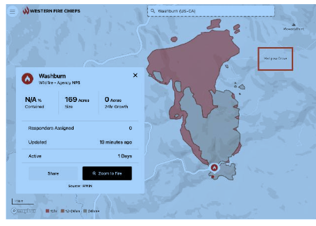
The Fire Map is designed to be easy to read and easy to follow. It contains as much information as is available at any given time and adds a new dimension to tracking a fire’s activity. In addition to information about where the fire is burning, it also indicates where those managing the fire suppression believe it is headed. A recap of every fire and its location is also provided. All of this is based on data pulled from the sources named above as well as data provided by people on the fireground. The result is a robust website that will aid the Fire Service, all public safety agencies, the media, and citizens with the best and latest information about wildfires.
Congratulations to the WCFA for identifying problems with how to provide existing fire information and then moving forward to design a website that makes it easier to see in near-real time what is happening on the ground and in the air. This website presents a great deal of information that is of value to all the audiences it was designed for. And as called for above, it can be viewed on tablets and broadband smartphones in the field and kept up-to-date on a specific fire or a multitude of fires.
Fire Season
Fire season is no longer a season, it runs all year. When there were specific months that could be identified as high fire risk months, fire services could schedule when to bring on additional personnel from various sources and when to move equipment around to better position it to attack a fire in the early stages.
As we all know, with the drought in the west, fires are more frequent and larger, burning as fiercely at night as during the day. Years ago, fire fighters caught a break at night when the fire usually “laid down” and fire services could plan their strategy for next day. Those days are gone as well. If you check the fire reports, you will find it is not unusual to see a fire double or even triple in size over night.
Fire services modify their tactics as fires keep growing but it takes many resources to gain an upper hand on a large wildfire. If aircraft cannot fly to drop water and fire retardant at the edges of the fire, ground crews have to work that much harder.
Communications for wildfire incidents are critical for logistics, air-to-group, and fire crews on the ground. Land Mobile Radio (LMR) has always been a must-have for wildfires but now FirstNet (Built with AT&T) is also critically important. This is one of many reasons FirstNet deployables stand at the ready to be sent out to make sure voice, data, and video traffic are supported. And now this includes information gleaned from the Fire Map and other sources.
Vendors continue to work on ways to increase broadband coverage at fires. Today, in addition deployables there are suitcase-size systems that can be carried into an area and set up to provide broadband and/or LMR coverage where it is not available. Drones that can stay in the air for hours, either tethered or free-flight, are becoming more important but like any drone at a fire scene, they have to be well coordinated with helicopters (helos) and fixed-wing aircraft to keep everyone safe. We have all heard stories about some media outlet or citizen flying a drone into a fire area, thereby requiring all aircraft in the area to vacate the air space until the drone is cleared out of the area.
As information becomes more accurate on the Fire Map website, for example, and communications become more robust, fire services will have more tools at the ready. Still, the only way to put wildfires out is with people and equipment on the ground and in the air, and communications are vital to coordinating all the resources on scene and staged. Better communications on the scene and back to the Emergency Communications Center makes everyone more effective and keeps them safer.
APCO Week
If you attended APCO this week, you probably noticed I was not there this year. However, in lieu of being there in person, I will be reviewing all of the good info in Urgent and Mission Critical and whatever else I can find. In the meantime, I thought I would ask any and all of you who did attend APCO if you would answer one or more of the following questions:
- What was the best new device you saw in the exhibit hall?
- If you attended some or all of the sessions, which one would you rate as the most informative?
I am looking forward to your responses, I will include them and other information I will have collected in an upcoming Advocate column. Thank you in advance.
For my part, I hope a few devices are announced that will serve both LMR and broadband, and perhaps we will see a High-Power User Equipment (HPUE) handheld device. (This will be difficult to do since the user must be kept safe and the battery life needs to make it through an entire shift.)
BlackBerry Phone Update
Last year, we were promised a brand-new Android-based BlackBerry phone. Since then, the website has been updated, always with delay announcements. Then this month there was a statement that the BlackBerry phone is dead and MAY come back (perhaps) under the Uniden brand name. What I find interesting about is that Siyata, the company that makes the PTT iOS device I wrote about earlier this year, has a Uniden product listed on its website. I have to wonder if Uniden will end up with what now would appear to be a BlackBerry of a different flavor.
I started using a BlackBerry when I received a beta test unit and I remained an ardent BlackBerry user for many years. I have a collection of almost every BlackBerry made and was hoping to add another one to the display case after I tried it out for a while. So, once again, all of us who were hoping to see a reincarnated BlackBerry smartphone will have to do without.
We will not be publishing an Advocate next week due to other commitments but the Advocate will return the following week.
Until next time…
Andrew M. Seybold
©2022, Andrew Seybold, Inc.

Be the first to comment on "Public Safety Advocate: Wildfire Information, APCO Week, BlackBerry Phone?"