
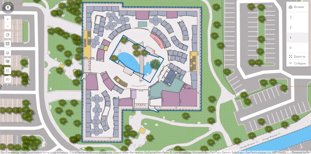
Geographic information systems (GIS) has transformed the map, a tool public safety organizations have used for over a century. Instead of simply knowing where to go, we understand the how, what, and why about every place. Esri has been at the forefront of that transformation since the company was founded in 1969. Today, thousands of local, state, and federal safety agencies across the United States use Esri’s ArcGIS technology to respond with situational awareness powered by location intelligence.
The next frontier of public safety GIS is indoors
When an emergency occurs inside a school, hospital, apartment building, airport, stadium, or other complex facility, a street address is only the beginning. O’Hare International Airport has one street address, but if someone is in cardiac arrest at gate B17, responders need far more specificity.
911 telecommunicators and first responders need indoor context: the floor, room, nearest entrance, stairs or elevators, AEDs, fire suppression equipment, utility shutoffs, hazards, and other information that helps them respond quickly and safely.
That’s why indoor GIS data matters. A floor plan helps responders understand a building, but structured GIS data allows software to search, analyze, combine, and share that information. It can calculate routes to an incident, identify the nearest AED, or display live video from nearby cameras.
Indoor GIS needs connectivity
Even the most accurate indoor map has limited value if responders cannot access it in the field. Without a dependable network, we are not far removed from printed floor plans stored in a lock box, fire engine map books, or a file cabinet in a 911 emergency communications center.
Public safety broadband, and FirstNet in particular, provides the communications substrate that makes indoor GIS actionable. Priority and preemption help data move during congestion, while broadband capacity supports indoor maps, 360-degree imagery, building-system information, sensor data, and real-time video.
A telecommunicator can locate a caller within an indoor context and see nearby rooms, entrances, and critical assets. Responders can receive that same operational picture before arrival and use it throughout the incident. Live building information adds context, helping agencies and disciplines work from the same information.
The map – and critically, the GIS data behind it – becomes a fusion point for operational information. It supports shared situational awareness and, ultimately, shared situational intelligence: understanding what is happening, what it means, what risks exist, and what action to take next.
FirstNet and the opportunity to scale indoor GIS
Public safety needs interoperable indoor GIS data for schools, campuses, government, commercial and residential buildings, transportation facilities, entertainment venues, and other difficult-to-navigate places. That data should be accessible through the systems responders already use – not scattered across disconnected apps, websites, or file repositories.
That requires a reliable, public-safety-grade broadband network. And that’s where FirstNet becomes critically important.
It also requires an enterprise geospatial foundation. ArcGIS serves as a trusted platform for creating, maintaining, analyzing, and sharing indoor GIS data. Its own complete system, ArcGIS Indoors supports indoor mapping at scale, while ArcGIS Indoors Floor Plan Editor makes creating and updating maps accessible to people who are not GIS experts. ArcGIS Hub and ArcGIS Enterprise can help organizations securely share the right information with the right people.
Indoor GIS provides the intelligence. FirstNet makes that intelligence available. Together, they can give public safety something far more valuable than a map: a shared, connected operational picture accessible anywhere, in the heat of the moment, when seconds matter most.
To learn more, visit Esri Emergency Communications.
Be the first to comment on "A Map Is Only as Good as the Network That Carries It"